GeoSuite

A Commercially Available Toolkit for the Tactical Leader
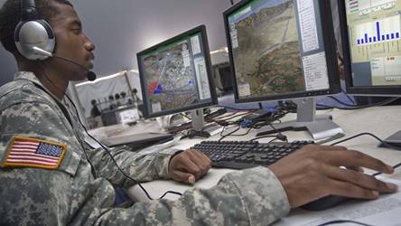
GeoSuite empowers tactical leaders to efficiently analyze, plan, rehearse, execute and review strategic operations. Backed by an innovative, resilient network solution, GeoSuite utilizes an intuitive map-centric interface including unique multimedia tools, advanced planning capabilities and visualizations specifically focused on the operational environment. With a focus on rapid dissemination and sharing of critical information, GeoSuite delivers real-time actionable intelligence and situational data in Disconnected, Intermittent, and Limited (DIL) environments.

Mission Planning & Execution
- Geo-referenced visualization for information pattern discovery
- Concentration on specific areas of operation for focused data analysis
- COA development and analysis
- Military standard symbology and support for custom symbol sets
- ‘Drag & Drop’ utilities and simple user interactions

Network Adaptability & Collaboration
- Information sharing across the full spectrum of operations, connecting field users to command centers
- Share geo-referenced information and link other users to ongoing activity without leaving the application
- Users collaborate using text, graphics, pictures, video clips, audio clips, KML/KMZ overlays, Microsoft Office® documents, and military symbology
- Minimizes bandwidth, while maximizing delivery of content (events, people, tasks, reports, etc.) and multimedia to tactical-edge users

Situational Awareness
- Near real-time visualization of critical information from multiple sources
- Centralized monitoring and location information of assets and sensors on the network
- Customizable alerts and notifications
- Integrated video viewer for live feeds

GEOGRAPHIC ANALYSIS
- Best in class imagery available even in fully offline mode
- Single point of entry rich with dynamic and customizable map layers
- 2D and 3D maps featuring integrated terrain and route analysis
- Integrated map tools allow quick and accurate measurements of distance, bearing, triangulation, line-of-sight, area, point-of-origin estimation, and radius for rapid situational assessment
Public Safety Solutions
From supporting search and rescue operations with Texas Task Force One to providing a common operating picture for law enforcement agencies providing security at the Super Bowl, GeoSuite has become the go to solution for first responders and public safety agencies. To learn more about these solutions, check out nFocus Solutions, a General Dynamics exclusive provider of GeoSuite within the United States with the primary focus on sales to commercial industries as well as state and local opportunities: nFocus.com.